Tropical Storm Edouard was approaching the northwestern Gulf Coast on Tuesday afternoon, bringing tropical-storm-force winds and a growing flash-flood threat to parts of Texas and Louisiana.
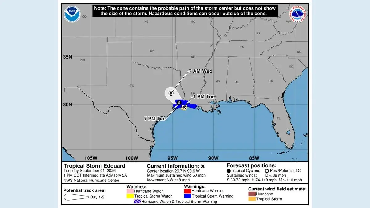
In its 1:00 p.m. CDT advisory on September 1, the US National Hurricane Center placed Edouard about 25 miles southeast of Port Arthur, Texas, and about 20 miles west-southwest of Cameron, Louisiana. Maximum sustained winds were 50 mph, and the storm was moving northwest at 8 mph.
The NHC said the center was expected to reach the coast later Tuesday and move inland over southeast Texas during the night. Little change in strength was forecast before landfall, followed by rapid weakening over land.
Latest update: This article is based on the NHC's 1:00 p.m. CDT (18:00 UTC) advisory on Tuesday, September 1. Weather conditions and warnings can change quickly. Residents should check the latest NHC updates and their local National Weather Service office.
Where will Tropical Storm Edouard make landfall?
The center was forecast to cross the northwestern Gulf Coast within the warning area, close to the Texas-Louisiana border. The exact point matters less than the wider hazard zone: heavy rain, coastal flooding and gusty winds can occur away from the center.
Edouard is a small tropical cyclone. Tropical-storm-force winds extended up to about 25 miles from its center in the afternoon advisory. That compact structure can create sharp differences over short distances, but it does not eliminate the flood danger from rain bands spreading inland.
The forecast called for the storm to continue northwest through early Wednesday. Once inland, its circulation should weaken quickly, although tropical moisture can continue producing heavy rain after the wind speeds fall below tropical-storm strength.
Which areas are under a tropical storm warning?
A tropical storm warning was in effect from Port Bolivar, Texas, to the Vermilion/Iberia Parish line in Louisiana.
That warning means tropical storm conditions are expected somewhere within the specified area. The NHC discontinued the earlier hurricane watch and storm surge warning in the 1:00 p.m. update, while a National Weather Service coastal flood warning covered portions of the northwestern Gulf Coast.
People outside the tropical storm warning should still monitor local alerts. Flood, tornado and severe thunderstorm warnings are issued separately and can cover inland counties or parishes beyond the coastal wind-warning zone.
How much rain could fall?
The NHC forecast 3 to 6 inches of rain across parts of the Upper Texas Coast and inland through east-central Texas. Isolated totals could reach 9 inches. Far southwestern Louisiana could receive 2 to 4 inches.
Those amounts are enough to produce flash flooding, especially in low-lying neighborhoods, urban areas and places where drainage systems become overwhelmed. River flooding was also possible.
Rainfall impacts do not depend only on the total. A short burst of several inches can be more dangerous than the same amount spread across a day. Drivers should never enter water covering a road; depth and current are difficult to judge, and the road surface may have been damaged.
Storm surge and coastal flooding forecast
The combination of surge and normal tide could raise water 1 to 3 feet above ground level somewhere between High Island, Texas, and the Vermilion-Cameron parish line in Louisiana, if peak surge arrives near high tide.
The highest water was expected along the immediate coast near and to the right of Edouard's center. Surge effects vary greatly depending on track, wind direction, tides and local geography. Residents in vulnerable coastal areas should follow instructions from local emergency officials even though the broader storm surge warning was discontinued.
Is there a tornado risk?
The NHC said a tornado or two was possible Tuesday afternoon and evening across parts of southwest Louisiana and southeast Texas.
Tropical tornadoes can form quickly inside outer rain bands and may be difficult to see in heavy rain. Keep wireless emergency alerts enabled and move to a small interior room on the lowest floor of a sturdy building if a tornado warning is issued.
What residents should do before landfall
The window for preparation is short. People in the warning area should focus on immediate, practical steps:
- Charge phones and backup batteries.
- Keep weather alerts enabled overnight.
- Move vehicles away from flood-prone streets where possible.
- Secure outdoor furniture and loose objects.
- Avoid beaches, jetties and flooded coastal roads.
- Know two routes to higher ground.
- Keep medicines, drinking water, flashlights and important documents ready.
- Follow county, parish and city emergency instructions.
If local officials tell residents to leave, the local order should take priority over a general online forecast.
Will Edouard become a hurricane?
Earlier forecasts allowed for the possibility of Edouard approaching hurricane strength. By the 1:00 p.m. advisory, the hurricane watch had been discontinued and the NHC expected little change before landfall.
A hurricane has maximum sustained winds of at least 74 mph. Edouard's sustained winds were 50 mph at the advisory time. Even without reaching hurricane status, the storm can produce dangerous flooding, coastal water rise, power outages and isolated tornadoes.
Storm category is a wind measurement, not a complete measure of risk. For Edouard, rainfall and flash flooding may be the most widespread hazards.
What happens after landfall?
Edouard should weaken rapidly as its center moves inland over southeast Texas. The wind threat will diminish, but heavy rain can continue farther north and west along the track.
Residents should not assume the danger has ended when the center crosses the coast. Flooding frequently develops during or after landfall, and rivers may rise later. Power lines, damaged trees and contaminated floodwater can also remain dangerous after winds subside.
Bottom line
Tropical Storm Edouard was close to landfall near the Texas-Louisiana border on Tuesday afternoon with 50 mph winds. A tropical storm warning extended from Port Bolivar to the Vermilion/Iberia Parish line, while heavy rain created a flash-flood threat across the Upper Texas Coast and into east-central Texas.
The storm was not expected to become a hurricane in the final hours before landfall, but that does not make it harmless. People in the region should monitor official warnings, stay off flooded roads and be prepared for rapidly changing conditions through Tuesday night and Wednesday.
Frequently asked questions
Where is Tropical Storm Edouard? At 1:00 p.m. CDT Tuesday, the center was about 25 miles southeast of Port Arthur, Texas, moving northwest at 8 mph.
How strong is Edouard? Maximum sustained winds were 50 mph, with higher gusts.
Which places face the highest rainfall risk? Parts of the Upper Texas Coast through east-central Texas could receive 3 to 6 inches, with isolated totals up to 9 inches.