At least two people have died and more than 20 may be missing after a violent flash flood swept through the inner Grand Canyon, destroying trails and footbridges and forcing dozens of hikers to be evacuated by helicopter.
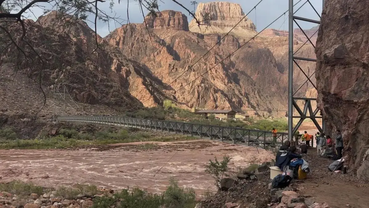
Heavy rain on Saturday sent mud, boulders and debris through Bright Angel Creek, the side canyon that runs from the North Rim toward the Colorado River. Search-and-recovery teams continued working along the canyon floor on Monday as the National Park Service tried to determine how many people remained unaccounted for.
The South Rim stayed open for daytime visits, but overnight lodging and concessions were closed. Phantom Ranch, the North Kaibab Trail and other flood-damaged areas remained shut, and officials urged visitors to stay away from the affected inner canyon.
Grand Canyon flood: latest confirmed information
- At least two bodies have been recovered
- One victim was identified by age as a 46-year-old man
- The Park Service is seeking information about more than 20 people who may be missing or unaccounted for
- At least 62 people were evacuated from Phantom Ranch and the North Kaibab Trail by Sunday morning
- Trails, footbridges and other inner-canyon infrastructure were destroyed or damaged
- The Transcanyon Waterline was damaged, leaving limited park water reserves
- Additional thunderstorms were expected early in the week
The number of missing people is not yet a confirmed casualty figure. “Unaccounted for” can include visitors who left the area safely but have not yet contacted authorities. Officials must compare permits, lodging records, witness reports and family inquiries before establishing an exact number.
Where the flooding hit hardest
Bright Angel Creek suffered the most severe damage. The creek follows a narrow corridor through the canyon and meets the Colorado River near Phantom Ranch, a historic lodge and campground accessible by trail, mule or river.
During intense rain, a narrow canyon can concentrate runoff from a much larger area. Water rises quickly and carries rocks, tree limbs and construction material, turning the flow into a debris-filled torrent.
The North Kaibab Trail follows Bright Angel Creek for parts of its route. That placed hikers, bridges and trail infrastructure directly in the flood path.
The remoteness of the inner canyon complicates every part of the response. There is no road access to Phantom Ranch, so rescuers rely on helicopters, trails and river operations. Damaged footbridges can isolate people who are physically close to safety but separated by fast water.
Helicopter evacuations from Phantom Ranch
The National Park Service reported that 62 people had been evacuated by helicopter from Phantom Ranch and the North Kaibab Trail by Sunday morning.
Air evacuation is the fastest option when trails are destroyed, but helicopters are limited by weather, visibility, landing space and the need to prioritise injured or vulnerable people.
One survivor said a ranger directed guests across a footbridge to higher ground about ten minutes before the bridge washed away. The account illustrates how rapidly conditions changed and how important immediate instructions were.
Arizona Representative David Schweikert was also in the canyon, rafting with friends near Bright Angel Creek. His group heard the flood approaching and later hiked out safely.
Search for the missing continues
Search teams are working along the canyon floor and around debris fields where people may have been swept downstream or trapped by damaged infrastructure.
The Park Service asked for information about more than 20 individuals. Families who believe someone is missing should use official Park Service channels rather than relying on social-media lists, which can contain duplicated names or people who have already been located.
Search-and-recovery work after a canyon flood can take time. Crews must inspect unstable banks, deep pools, debris piles and remote stretches of river while protecting rescuers from another storm.
Visitors who left safely should contact family members and any authority that may be tracking them. Closing an information gap can allow search teams to focus resources on people still at risk.
Major damage to the Transcanyon Waterline
The flood damaged the Transcanyon Waterline, which carries water from the inner canyon for use in park facilities.
With the system temporarily out of operation, Grand Canyon National Park has limited water reserves and has introduced significant conservation measures. Overnight accommodations and concessions on the South Rim were closed even though daytime access remained open.
The waterline has long been a critical and vulnerable piece of park infrastructure. Damage can affect lodging, restaurants, staff housing and visitor services far from the original flood zone.
Travellers should not assume that an open entrance means every service is available. Carrying water is essential, but visitors must also check official guidance because restrictions can change as storage levels and repair work develop.
Which Grand Canyon areas are closed?
The exact closure map may change, but officials said several hiking and lodging areas affected by the flood were fully shut.
Visitors should expect closures around:
- Phantom Ranch
- North Kaibab Trail sections in the flood zone
- Bright Angel Creek crossings
- Damaged footbridges and nearby trails
- Overnight South Rim accommodations and concessions affected by water restrictions
The South Rim remained open for daytime use on Monday. That does not make travel into the inner canyon safe. Rangers asked people to avoid the flood-stricken areas while search operations and infrastructure assessments continue.
Before travelling, visitors should check the National Park Service's Grand Canyon alerts page and current weather warnings. Third-party hiking apps may not update closures quickly enough during an emergency.
Why flash floods are especially dangerous in the Grand Canyon
Rain does not have to fall directly over a hiker to create a flood. Water can collect miles away and race into a side canyon with little visible warning at the victim's location.
Steep rock walls leave few escape routes. Trails may run beside or cross normally small streams, and the roar of water can arrive only shortly before the surge.
Floodwater also behaves differently from clear river water. Mud and rocks increase its destructive force, while debris can strike people and demolish bridges. A shallow-looking crossing may be strong enough to knock down an adult.
The safest response is to move immediately to higher ground and follow ranger directions. People should never enter moving floodwater or attempt to retrieve equipment once a creek begins rising.
Safety guidance for upcoming visitors
Anyone with a Grand Canyon booking should verify its status directly with the park or authorised concessioner.
Key precautions include:
- Check National Weather Service and Park Service alerts before entering a trail.
- Do not hike into a closed area, even if conditions appear calm at the rim.
- Know the nearest route to higher ground when travelling beside a creek.
- Carry enough water for delays and understand that park refill points may be unavailable.
- Tell someone your route and expected return time.
- Keep a charged phone or emergency communication device, while recognising that canyon coverage is limited.
- Turn around immediately when rangers issue an evacuation order.
Summer and early-autumn storms can be highly localised. A clear sky overhead does not rule out dangerous runoff from another part of the watershed.
How the flood affects the park
Grand Canyon National Park drew about 4.4 million visitors last year, making it one of the most visited sites in the US national park system.
The immediate priority is locating missing people and protecting survivors. After that, engineers must inspect bridges, trails, water pipes, buildings and utilities before deciding what can reopen.
Repairs in the inner canyon are unusually difficult because material often must be flown in or carried by trail. Rebuilding could take months, and some routes may remain closed long after general visitor services resume.
The disaster is also a reminder that national parks are active natural environments, not controlled attractions. Popular routes can become dangerous in minutes, and emergency access is far slower below the rim than in a city or roadside destination.
What to watch next
The most important updates will be the confirmed number of missing people, identification of the victims, progress of the search and a detailed closure schedule.
The Park Service is also expected to provide more information about water conservation and repairs to the Transcanyon Waterline. Visitors with reservations should monitor official notices rather than wait for individual cancellation messages.
With more thunderstorms possible, crews and visitors face continuing risk. Conditions around Bright Angel Creek may remain unstable even after water levels fall because banks, bridges and debris piles have been weakened.
Sources
- Reuters: At least two dead in Grand Canyon flooding and more than 20 may be missing, August 31, 2026
- National Park Service: Grand Canyon National Park alerts and emergency updates
- National Weather Service: Arizona flash-flood and thunderstorm guidance
Thumbnail: Helicopter operations during Grand Canyon flooding on August 29, 2026. Image by Wieke De Boer via Reuters.